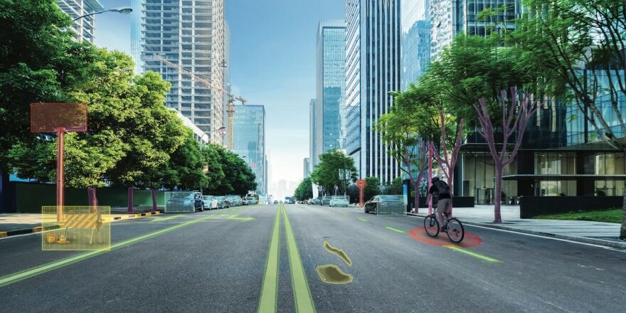
Mobileye® Data Services™ help communities address mobility and infrastructure challenges by providing unique data. The use cases are diverse, the needs enormous.
Traffic 2.0: City and transit officials are working hard to simplify and improve urban mobility. Whether it’s congestion avoidance, more sustainability in transportation planning, or the expansion of bike lanes, road infrastructure data collection is an essential component in addressing these projects. But in this area, in particular here in Germany, there is a comprehensive need for digitization. Until now, local authorities have had to send their own surveying fleets out onto the roads at regular intervals to collect inventory information and prepare mobility analyses in time-consuming and therefore cost-intensive, small-scale work. An approach that is not sustainable in an increasingly digitized world.
The solution that provides up-to-date data on any road infrastructure equipment, its quality and mobility information already exists. Local governments, traffic planners and urban planners get exactly the accurate mapping they need at their fingertips with Mobileye® Data Services™.
This road data is generated over millions of trips by vehicles equipped with Mobileye’s driver assistance systems. This makes it possible to capture real-world dynamics and the changing mobility landscape of a city’s streets – all without the need for dedicated survey vehicles. Mobileye mobility intelligence can help local governments and departments of transportation address mobility and transportation challenges by providing them with unique data on both driver behavior and pedestrian and cyclist mobility, as well as traffic flow (with lane-level precision) and more.
Reliable data basis
Vehicles equipped with Mobileye’s driver assistance systems – passenger cars and commercial vehicles – detect pedestrians, cyclists and other vehicles while they are still on the road. The systems not only reliably detect the surroundings, but also relate the interactions: Mobileye’s technology does this by using a single camera to scan the road ahead, identify potential hazards and warn the driver. This data, collected from multiple vehicles and trips via « crowdsourcing, » can be used for more than just momentary driver support. They are additionally analyzed and summarized for exploitation in Mobileye data services. This is done fully automatically, meaning that the condition assessment is objective and consistent for the entire road network – without human intervention. The data is also read out seamlessly – either via direct transfer to the company’s own database or via a suitable interface to the GIS platform. All processes are subject to the strictest data protection guidelines and the data is processed anonymously.
Where mobility intelligence comes into play
The unique data Mobileye can provide has many applications. For example, it can be used to identify driving behavior factors that contribute to an increased traffic risk. This includes the detection of near-accidents or blind spots where the brakes are applied particularly hard. In addition, users can identify specific road sections and intersections where traffic jams repeatedly occur and take them into account in their own planning. From the resulting road risk assessment, dangerous road sections can be quickly and efficiently identified and subsequently defused or even eliminated by taking appropriate measures in the routing.
The assessment of road infrastructure also plays an important role with regard to the mobility of the future. In a few years, (partially) autonomous vehicles will no longer be a rarity on Germany’s roads. But are our roads ready for this today? While short sections of road without lane markings, for example, are usually no obstacle for a human driver, this can pose significant problems for a robotic vehicle. Therefore, if care is taken today to prepare the road infrastructure for the challenges of tomorrow, new technologies will be deployed more quickly – and cost-intensive, subsequent adaptations will be avoided.
Cities that have some catching up to do in terms of bicycle-friendliness can also use current data on the volume of cyclists to analyze the use of existing bike lanes and locate urgently needed bike lanes at accident blackspots. This possibility makes another important contribution to increasing the safety of all road users. The situation of pedestrians can also be improved with the help of intelligent mobility data: The maps show, for example, the current locations and procurement of crosswalks, the volume of pedestrians in road traffic, and accident hotspots. Decisions on where to take additional measures to improve safety can be made in an unbiased and reliable manner using Mobileye data services.
When local governments incorporate such data into their decisions, they not only save money through more efficient decision-making. They can also support grant and funding applications with relevant and up-to-date mobility data. In addition, the effectiveness of these infrastructure investments can be measured and proven quickly and easily. This not only creates planning security for future investments, but also makes it possible to obtain a comprehensive picture of one’s own infrastructure at any time.
A comprehensive solution
Mobileye® Mobility Intelligence is part of the comprehensive Mobileye® Data Services™ offering that enables organizations to more efficiently keep an eye on their infrastructure, extend the life of roads, and improve traffic flow and mobility. The challenges posed by future mobility can be solved efficiently, cost-effectively and evidence-based.


